OPERATION PINCER II – 1986
OVERVIEW
July Rain for Los Angeles, California
In presenting on the Internet an account of a successful etheric rain engineering operation of great complexity, information previously undisclosed concerning the preludes to Pincer II is essential. Especially is this true for thousands of persons worldwide, who will be making their first acquaintance with etheric rain engineering via this website. This applies both to intelligent laypersons and professional people. The technology employed in Pincer II is no longer used as a separate entity by ERE of Singapore, but is incorporated in current technology, including AEREO ( Airborne Etheric Rain Engineering Operations). The principles employed in Pincer II are basic to the art, and likely to be enduring.
BACKGROUND
The road to Pincer II was long and hard. Pincer II
did not just happen, like a rabbit pulled out of a
magician’s hat, or lucky coincidence. Many shortfalls,
pitfalls, embarrassments and failures accompanied progress
along a lengthy empirical pathway. On that pathway
there was no conventionally-accepted, classical undergirding
for the project. There were no authorities that we
could consult for guidance. This was truly pioneering,
self-financed and independent.
In scale and scope, Pincer II was a geographically large and ambitious venture – unequalled to this day. Pincer II climaxed a series of July rain engineering operations beginning in 1976, all with the same purpose. The objective was to conquer a well-established barrier: the statistical rainlessness of Los Angeles in the month of July. Successfully overcoming this century-old barrier, via etheric rain engineering, would provide fundamental evidence of the validity and value of etheric engineering.
DOCUMENTATION
U.S. Federal laws provide that such weather modification
operations be reported IN ADVANCE to the National
Oceanographic and Atmospheric Administration of the
U.S. Government. By appending an engineering drawing
to our Federal filing for Pincer II, we would show
clearly how it was intended to bring rain into statistically
rainless Los Angeles in July. U.S. Government radar
fax maps would provide third-party confirmation and
irrefutable objective evidence of where rain formations
developed, and how they moved and thus brought rain
into Los Angeles – were the project successful.
Simply expressed, we would define in advance what we intended to do, and how we intended to do it, using the official government filing procedure. We would then execute the project. Government measurements and radar maps would objectively confirm – or refute – our success.
EARLY OPERATIONS
In the period between 1968 and 1976, many exploratory
operations via etheric rain engineering techniques
were carried out, using for the most part, extremely
simple “rack” units grounded into flowing water. These
crude assemblies of 100 or more hollow tubes, were
not to be compared to the elegant cloudbuster designs
of Dr. Wilhelm Reich, who devised the basic techniques
involved. Our large and rough rack units nevertheless
mobilized vast amounts of ether. Such units provided
basic practical experience in manipulating the ether,
and confirmed not only its objective, physical existence,
but also its technical accessibility. These huge,
crude installations were sufficiently powerful that
their results “forgave” and compensated for our amateur
ineptitude and inexperience. Evidence that the weather
could be influenced over enormous distances and areas
grew as the years passed.. Confidence that such operations
could be successfully mounted, developed naturally
from consistent, practical participation in a new,
scientifically-based art. This was on-the-job education.
Most scientists denied the existence of the ether,
and there had been squabbling over the ether by great
minds for more than a century. The practical world
was our venue and it was ruled by results.
Southern California was the scene of most operations. We became familiar at first hand with the regional weather and climate, in the particular way they are influenced by etheric flows and factors. This enhanced and illuminated existing, formal knowledge of the region. As our capabilities, equipment and operating acumen improved, we became able to engineer relatively astonishing conditions. The etheric continuum we were accessing was clearly of high power. The resultant effects were frequently so vast that they strained the credulity even of enlightened, well- disposed people who were convinced of the ether’s reality. One came to think in states and even continents, while aware that in decades ahead, one would have to think on a planetary scale with etheric engineering. Hundreds of miles in distance, and thousands of square miles in area were involved in some of these primitive, pioneer operations.
IDENTICAL PRIMITIVE APPARATUS, IN THE 21ST CENTURY, CAN STILL READILY REVERSE DROUGHT IN MANY CLIMATES, WHEN DIRECTED BY AN EXPERIENCED RAIN ENGINEER. POWERFUL POLITICAL FORCES PLAN TO ‘PRIVATIZE’ WORLD WATER RESOURCES FOR THE EXPLOITATION OF SUFFERING MANKIND.
THE EFFECTIVE RESPONSE TO WORLD DROUGHT IS TO TECHNICALLY ACCESS BILLIONS OF TONS OF PURE WATER THAT FLOAT ABOVE THE EARTH, USING ETHERIC ENGINEERING. PINCER II EXEMPLIFIES THIS APPROACH.
MOISTURE FROM MEXICO
Establishing a large desert installation in Thousand
Palms Oasis, about 15 miles northeast of Palm Springs,
California, we grounded our apparatus into a 300 gallon-per-minute
irrigation flow. With this incredibly simple rig, we
found it possible in the searing summer months, by
using etheric engineering techniques, to draw a large
flow of humid air – and sometimes rain – from the
head of the Gulf of California in Mexico, into the
Coachella Valley region of the lower Mojave desert.
If the tubes at Thousand Palms were grounded into
the irrigation water flow, and left untended, humidity
in the lower Mojave desert rapidly built up to near-
intolerability for residents. Date crops verged on
ruin in such anomalous, highly humid weather.
Brief ON/OFF applications of this simple technique left no doubt that it was the rack units that were producing the humidification. Through such experiences, the basic technique of damming up a fundamental etheric flow, and thus diverting it around a fixed base, was developed. Modifications of regional weather could be initiated in this way. Once proved out, the desert humidification experiments were not repeated, for obvious reasons. Among the operational possibilities arising from these tests, was adaptation of the technique to an objective goal. Could we get the summer south-to-north flow of etheric force coming out of the Gulf of California in Mexico, to curve northwest into Los Angeles, before turning away northeastward in its normal fashion? Humid air from the region around the head of the Gulf of California, impelled by a south-north ether flow, normally feeds a curving summer “monsoon” moisture flow north and east to the Phoenix area in Arizona. Our intention was to shift this moisture-laden etheric flow more than 200 miles westward from its normal track, by means of etheric engineering. The distances involved, and the distortions we were to engineer into established weather patterns, were daunting. Amateur enthusiasm has the power to minimize such formidable obstacles. We already had abundant evidence of what even the simplest water-powered etheric projectors could do, and no skeptical academician had the power to verbalize away this practical experience.
1976-1986 RUN-UP
Every July from 1976 onward, we tackled some aspect
of the Herculean task of engineering rain into Los
Angeles. Practical experience proved over the years
that with existing techniques, knowledge and equipment,
we could come close to achieving our goal, but something
was still missing. Definitely needed was an additional
operating base well east of San Diego, California.
Such a base was required reliably to draw the summer
south-to-north ether flow out of Mexico and bend this
moisture-bearing ether flow west of the coastal mountain
range in southern California. Only then could the
moisture-bearing ether move up the coast west of the
mountains on its northward passage to Los Angeles,
guided in its final phase by our base on Point Fermin,
the southernmost tip of Los Angeles.
From early Thousand Palms Oasis experiments previously mentioned, we knew that it was possible to engineer rain into the Coachella Valley, but the marked tendency of such summer moisture was to drift rapidly eastward into Arizona, pushed by the fundamental west-to-east flow of ether that prevails in the northern temperate zone. The most promising route for Los Angeles rain originating in Mexico, was the coastal route, as previously described. Each July advanced our experience and capabilities further, but progress was slow. Around 1984, we secured the welcome cooperation of a forward-looking San Diego attorney and his wife, who was also an attorney. Surprisingly, both of these outstanding people had heard in law school of Dr. Wilhelm Reich and his legal battles. Both also were familiar with the career of the famous Californian rainmaker, Charles Mallory Hatfield. The latter’s operations had flooded San Diego in 1914. A memorial to Hatfield stands today at the Morena Dam, not far from our benefactors’ home.
HATFIELD FLAT
We christened the lawyers’ mesa from which we could
henceforth make our July efforts, “Hatfield Flat.”
From1200 feet above sea level and 16 miles east of
San Diego, Hatfield Flat looked directly south into
Mexico.
There was no doubt about the tremendous leverage possible from Hatfield Flat on Mexican moisture. Early operations quickly verified, via numerous all-time record July humidity levels in the San Diego region, that we were finally closing in on our longtime objective. Thunderstorms, lightning and rain sometimes battered Hatfield Flat, on one occasion for several hours. This proved the tactical value of the base. Storm damage to our warm-hearted benefactors’ property was accepted with grace and good humor.
FLYING ‘H’ UNITS
The development at sea, in 1984-86, of Flying H geometric
units that did not require water grounding, further
advanced our project. Great flexibility came with the
Flying H. A water ground was not required, and they
introduced rotary motion into the technology. At this
time, Mr. Gino Segreti, a longtime resident of Desert
Hot Springs, north of Palm Springs, kindly provided
access to his property. Known as “Fort Zinderneuf”
the Segreti property was ideally located for the purposes
of Pincer II. Gino became a beloved, trusted associate
and effective operator. He was for many months a shipmate
of Trevor Constable aboard SS Maui. He developed his
enthusiasm for rain engineering because of what he
saw happen on the high seas, during shipboard experiments.
These activities included the first marine use of
the Flying H prototype.
The base in Desert Hot Springs made further use of Thousand Palms unnecessary. The new base, 10 miles north of Palm Springs, was much closer to the Banning Pass – which connects the lower Mojave Desert to the Los Angeles Basin. The new geometry of this situation opened the prospect of using the strategically-placed Fort Zinderneuf base to push moisture entering the Coachella Valley from Mexico, through the Banning Pass and into the Los Angeles Basin. Experimentation with the Flying H units, and the new bases at Hatfield Flat and Fort Zinderneuf, led to high optimism that the goal of July rain in Los Angeles was within reach.
SPLITTING THE FLOW
Much practical experience now suggested that by splitting
the summer flow of ether out of Mexico, an effective
“pincer” effect could be created. One pincer would
be triggered from Hatfield Flat, following the line
of the coast northward to Los Angeles. The other, interior
pincer in central southern California, would follow
the natural “waveguide” provided by the sunken terrain
in which lies the Salton Sea.. This large inland body
of salt water essentially attracted any ether flow
moving northward out of Mexico, guiding the ether flow
along the massive trench that holds the Salton Sea,
all the way to Fort Zinderneuf, 10 miles north of
Palm Springs. “The Fort” had virtual line-of-sight
to the Salton Sea from 1200 feet above sea level. Fort
Zinderneuf equipment could block further northward
progress of any rainy formations, and steer them into
and through the Banning Pass to enter the Los Angeles
Basin from east of that city. These were the two arms
of the Pincer. A supplementary base was activated at
3400 feet above sea level on the north side of the
Banning Pass, to facilitate and ensure the passage
of any rain through the Pass.
This was the fundamental etheric engineering concept that led to the Pincer operations. There were two operations so named.. The first Pincer, in 1985, fell short of success, but proved the basic conception to be correct and feasible. Changes and adjustments were made for Pincer II, scheduled for July of 1986, and the success of this operation is now history. The engineering information presented in this background summary, should dispel any notion that Pincer II was an off-the-wall accident. Our thinking had been expanded along with our experience over the previous 16 years, including a new factor that had eluded us for many years.
INFLUENCE OF THE MOON
The extended period of experimentation in the southern
California region eventually made us aware of an especially
vital etheric component to success – the moon. Practical
provings convinced us that the fundamental west-east
flow of ether in the northern temperate zone, was keyed
to moon phases. The chief effect observed was that
the west-east ether flow peaked at full moon, and then
collapsed in the ensuing period, before recycling itself
to maximum flow at the next full moon. This west-to-east
etheric “push” was primarily responsible for the normal
south- to-north summer monsoon flow of moisture-bearing
ether from Mexico, curving northeastward to the Phoenix
area, once this flow moved clear of the head of the
Gulf of California.
The west-east ether flow, and the south-north ether flow of the northern hemisphere summer are separate functions of the ether, but to some degree they mutually influence each other. In the case of the planning for Operation Pincer II, full moon and the days immediately following, would be the critical period when the possibility of “bending” the rain-bearing etheric flows out of Mexico, more than 200 miles to the northwest of their normal track, would be greatest. Immediately following full moon was the time for us to make a maximum effort with Pincer II. There would be minimal eastward shoving of the northward-moving, rain-bearing etheric flows from Mexico. Most of the month, there was too much eastward shoving on these flows for them to reach Los Angeles. The statistical rainlessness of Los Angeles in July had been identified as a complex function of regional etheric flows, including cyclic lunar influence on those flows.
This lengthy empirical and theoretical background to Pincer II has never been previously disclosed. Considerable sacrifice in pioneering this work was made by the late Irwin Trent, who toiled and tithed for over 30 years in silent dedication as dear friend and co-worker. The late Dr. James O. Woods gave of his considerable best in advancing this work, right up to the time that ill- health overtook him in the middle 1980s. His passing ended a memorable association of more than a quarter century. These two gallant gentlemen were indispensable contributors to Pincer II.
The Journal of Borderland Research in 1987 published the following account of Pincer II, which has been abridged here, in view of the extensive background detail in the foregoing. In the abridgement, the flavor of a recently completed operation has been retained.
FROM
THE JOURNAL OF BORDERLAND RESEARCH,
JAN-FEB 1987
Edited and Abridged
OPERATION
PINCER II
July Rain Engineering,
Los Angeles, California 1986
by
Trevor James Constable
The statistical chances of measurable rainfall at Los Angeles Civic Center in July of 1986, were “unequivocally zero” according to National Weather Service statisticians, quoted by the Los Angeles “Times” on 24 July 1986. Pincer II was a successful attack on this statistical barrier, using etheric energy technology and methods. Ten days prior to the project’s commencement, I filed the legally-required Initial Report with the National Oceanic and Atmospheric Administration (NOAA), the responsible Federal agency. A copy of the Report appears herewith. An engineering drawing filed with that Initial Report, is reproduced in simplified form here.
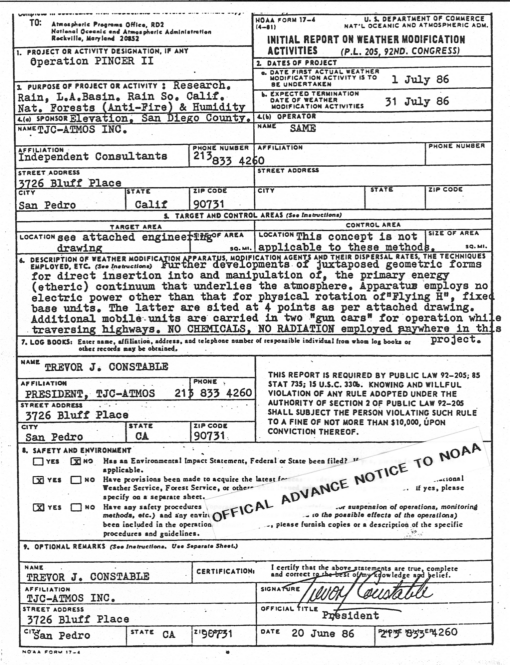
 |
|
Operational Plan for PINCER II This simplified version of the detailed engineering drawing submitted in advance to the U.S. government (NOAA), shows how it was proposed to engineer rain into Los Angeles in July 1986. BLUE flow is the normal July path of moisture from the Gulf of California into Arizona, producing the Arizona “monsoon” season.
RED flow is an engineered diversion of the blue flow.
The engineering causes moisture to move, as shown on
the map, into central Southern California. Bases
at “Fort Z” and Banning, “bend” this flow through the
Banning Pass into the L.A. Basin and to L.A. Civic
Center. This is one arm of the “Pincer.”
|
The drawing shows the precise routes by which it was intended to engineer moisture from Mexico into the Los Angeles Basin. A highly spectacular and notably unforecast thunder and lightning show accompanied the unforecast rain that made July of 1986 the wettest Los Angeles July in 100 years and the second wettest July of all time. The moisture arrived via the pre-specified routes, as the accompanying National Weather Service radar fax maps objectively reveal. Pincer II broke the statistical barrier.
About 16 years of avocational work preceded this overnight success. Bringing rain to Los Angeles city in July, requires that the normal, natural passage of Mexican moisture out of the Gulf of California northward and northeastward into Arizona, be diverted. An anomalous near-90 degree bend must be engineered into that flow, so that it will go some 250 miles northwestward out of its way. If such engineering is absent, the Los Angeles Civic Center rain gauge stays dry in July.
Our group today, views the weather as a geometric living structure. Control is available to anyone wise enough to approach the task minus the biases of mechanistic meteorology. Patience is also a prime requirement in grasping and using what is essentially a biogeometric technology. Planet Earth is a living organism, naturally reluctant to respond to the technology of chemical or electromagnetic insult.
Four operating bases were used in Pincer II.. Sited at Hatfield Flat (16 miles east of San Diego); at Fort Zinderneuf in Desert Hot Springs; on the Banning Bench in the Banning Pass; and on Point Fermin (the southernmost tip of the City of Los Angeles), these bases were manned by trusted associates. Trent at Hatfield Flat, Segreti at Fort Zinderneuf, Norgaard in the Banning Pass, and myself at Point Fermin.
Pincer II derived its name from the engineering intention to bring moisture into the L.A. Basin via two routes designed, like a pincer, to converge on L.A. Civic Center. The main effort would be via Hatfield Flat and San Diego, up the coast on the ocean side of the coastal mountains, passing east of Point Fermin and dropping into the rain gauge at Civic Center. The secondary arm of the pincer was via the Salton Sea and Banning Pass into the L.A. Basin from its eastern end.
Successful engineering of this kind, would unfailingly produce rains in the National Forest areas. Such rainfall was accordingly made a secondary goal of Pincer II, and was so stated in advance, in the Initial Report filed with NOAA on 20 June 1986.
Hatfield Flat, Fort Zinderneuf and Point Fermin were each equipped with the new Flying H units, developed in 1985-86 in dynamic tests on the high seas. The pivotal base at Point Fermin was also to test operationally the newest development of geometric weather guns: the Apache. This is a unit that works vertically, and induces implosive etheric reaction. The gross effect of such a device, is the appearance of a small, local low pressure system, which usually migrates. In maritime mobile tests, it has been possible with sea-going Apache units to inject miniature lows into the massive eastern north Pacific high, and to have these anomalous formations actually appear on official weather maps and fax charts.
Fixed-base operations were supplemented during the project by the use of two “gun cars” on the southern California freeways. Irv Trent operated extensively between San Clemente and San Diego, on a stretch of highway lying mainly in the critical southeast-to-northwest direction. Several years of operating gun cars has conclusively proved that they can exert regional effects under conditions favorable for their employment. In more recent times, growing freeway congestion everywhere has reduced their effectiveness, velocity being a key parameter in their functioning. Efficacy of the Flying H units more than made up for reduced effectiveness of the gun cars.
Flying H units are able to “trigger” etheric flows, and to exert substantial diversionary influence upon them once started. They can also act as local dams to an etheric flow. This can result in a dramatic rise in etheric potential “behind” the dam, encouraging rain. Flying H units will boost lightning to maximum intensity under storm conditions. Successful use of this apparatus does not depend simply on its acquisition, but rather, on comprehensive knowledge of etheric forces and experience in their manipulation. My own empirical experience dates from 1957, and has involved thousands of hours of such involvement.
Pincer II went through three distinct phases, in the course of which substantial anomalies were engineered into southern California weather. Phase 1 was the 4th of July weekend. Forecast to be hot, a very cool weekend ensued, at the end of which rain had fallen in cities as widely separated as San Diego and Pasadena. Phase 2 ended on 15 July 1986 with a two and a half hour thunder and lightning storm in San Pedro Bay, east of Point Fermin. The display was spectacular, and was enhanced by the Flying H on Point Fermin. Colored photographs were made of these events, with the camera shooting right through the field of the rotating Flying H. Rain resulted in Long Beach, contra-forecast.
Phase 3 was the critical main effort,. keyed to collapse of the west-east etheric flow after full moon on 21 July 1986. Moisture was entrained from Mexico on the 22nd, via both arms of the Pincer. A mass of moisture billowed along the interior (RED) Pincer route, and thrust into the L.A. Basin via the Banning Pass exactly as specified in the pre-filed engineering drawing. On the coast, initiation of Apache operations, in this period of west-east stagnancy, generated a small low off the coast of Los Angeles, which remained quasi-stationary. All units in concert brought moisture up on the GREEN ROUTE east of Hatfield Flat, and then offshore west of the coastal mountains. The rapidity with which all this was consummated on the night of 22/23 July 1986, caught the National Weather Service and the TV. forecasters flat-footed. Nothing of the spectacular events that transpired in the early morning hours of 23 July was forecast.
National Weather Service radar in Palmdale, California was sharply on its monitoring job. Passage of all moisture, in the way described – past Point Fermin and on into L.A. Civic Center – is recorded forever in their faxed radar summaries. Some of those radar fax maps accompany this presentation. The radar maps showed our engineering drawing brought to life in the real world.
The lightning displays were the most spectacular seen in southern California in living memory. The greatest number of lightning strikes occurred around Point Fermin – approximately 200 in number. (Photographs of this particular lightning activity, with the Flying H clearly presented in the scenario, can be viewed in the Lightning Gallery on this website). The booming light show stunned southern California, since no forecast or other intimation of such a violent event had been given on the weather segments of 11pm TV newscasts.
While events in the L.A. Basin seized local attention, including the wettest July day in 100 years, our attention was also on Segreti’s operations from Fort Zinderneuf in Desert Hot Springs, supported by the Banning Pass installation. Only the wild pyrotechnics in L.A. could have outclassed what went on as a result of the RED desert pincer. A thunderous light show took place against the face of Mt. San Jacinto, as scores of strikes slammed into its flinty slopes. More than an inch of rain fell in La Quinta. Hail appeared in the streets in the daytime, in July, in Palm Springs, Palm Desert and also in the Banning Pass. Hail there was marble-sized and noisy. Rain and hail drove Banning operator Norgaard indoors.
Pincer II produced sufficient rain in National Forest areas to overpower a number of stubborn forest fires. Some unofficial gauges reached four inches during the month of July, 1986. Combustibility of the national forests declined sharply. The secondary goal of the Pincer II was thus decisively achieved with significant public benefit.
The statistical facts of Pincer II are found in CLIMATOLOGICAL DATA, CALIFORNIA, July 1986, Volume 50, No. 7. In the two statistical divisions covering southern California, there are 100 official stations.
72 OF THE 100 STATIONS RECORDED RAIN IN JULY OF 1986.
Notable rains for the driest month of the dry season, were Anza 3.20", Cuyamaca 2.15", Idyllwild 1.73", Iron Mountain 1.47", Niland 1.50".
.18" of rain at L.A. Civic Center, the project bullseye, made July 1986 the wettest Los Angeles July in 100 years.
More than a century of official records provided invaluable statistical control. Pincer II showed for the first time in history that a complex etheric rain engineering operation could be designed, depicted in an engineering drawing, filed with the government in advance, and then executed successfully.
Control of basic natural forces has been a primal dream of the human race. Such control was clearly exerted in Pincer II, over a region of approximately 40,000 square miles. Humanity is being shown in this seminal work that already some “laws” of classical physics are apocryphal. The earth’s tomorrows, if they are to be at all, will be characterized by constructive, harmonious and cooperative working with Nature’s laws. This was demonstrated by ordinary men aware of such laws and minus large financial resources. Thus will we heal, sustain and transform the earth, Pincer II heralds the new ways.
The accompanying reproductions of official National Weather Service facsimile maps of regional radar echoes, complete with irrefutable official time signatures, show that the “Pincer” was engineered exactly as advised in advance, weeks before the actual operation.
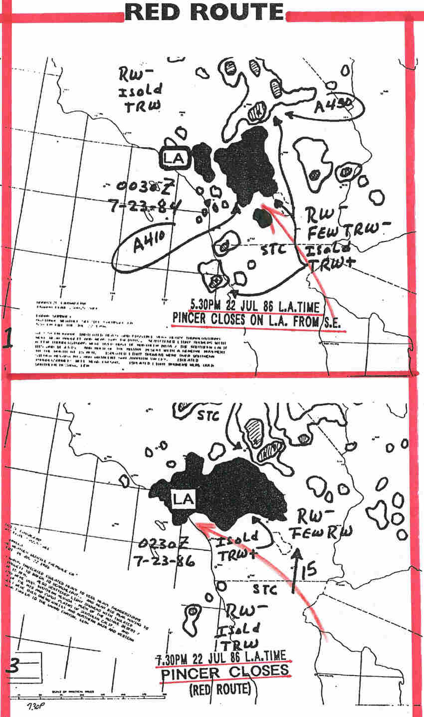 |
|
RED flow and RED Pincer came first, on the late afternoon and early evening of 22 July 86. The L.A. Basin is full of rain by 7.30pm.The RED Pincer has closed on L.A. Civic Center. |
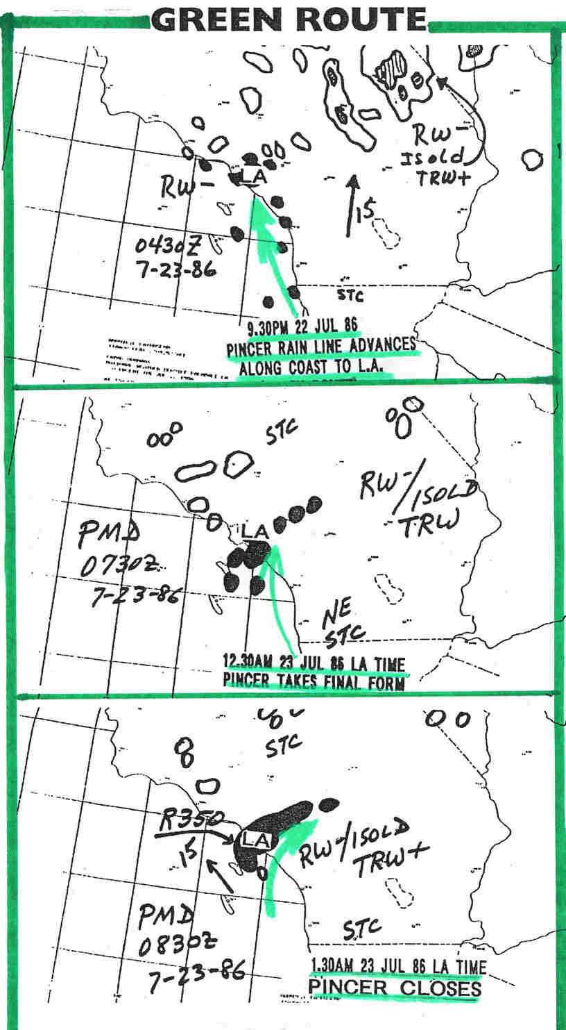 |
| GREEN flow began showing on radar at 9.30pm on 22 July 86, spreading from south to north up the line of the coast. By 12.30am on 23 July 86, GREEN Pincer has reached Point Fermin and beyond. By 1.30am, the City of Los Angeles has been enveloped from the south and the GREEN Pincer has closed. |